 Loading... Please wait...
All prices are in All prices are in GBP
Categories
- Home
- Giclee Prints
- Giclee Map Dutch Australia Guinea Terra Australis Tasman 1644
- Home
- Giclee Prints
- Maps and Charts
- Giclee Map Dutch Australia Guinea Terra Australis Tasman 1644
- Home
- Giclee Prints
- Maps and Charts
- Australia-Asia-Pacific
- Giclee Map Dutch Australia Guinea Terra Australis Tasman 1644
Product Description
Giclee, Southern Continent, Terra Australis, New Guinea, Dutch discoveries, Tasman, Bowen, 1644, New Zealand, New Guinea
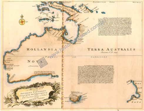
"A Complete Map of the Southern Continent-Surveyed by Capt. Abel Tasman & depicted by order of the East India Company in Holland in the Stadt House at Amsterdam"
An archival limited Edition Giclee process print from the original hand colored copper engraving by Emanuel Bowen that was published between 1744-1748 in London.
Image Size: 38cm x 48cm. (151/6 x 191/6 inch)
Archival Limited Edition Giclee /300. Issued with numbered certificate.
Description: On the return of Abel Tasman's Voyage in 1644, the Dutch published this aggregated map of the many Dutch visits in the 1600s: Peter Nuyts 1627,G. F de Witlandt 1628, Dirk Hartog, Capt.Pelsart, van de Lewin 1622, van Diemen 1642, to name a few. The name chosen is "Hollandia Nova discovered 1644". To the right of this title has been printed "Terra Australis, Discovered AD. 1644". In the 1740s Emmanuel Bowen brought attention to this map by re-engraving the original map, with all the Dutch names unchanged, although he does translate some cartographic descriptive notes: "NB. This is the Country (considered)...in the best Climate, in the World", "Here Captn Pelsart was wrecked" and the two blocks of typeset we see floating off the blank east coast of, what must be, a sizable land mass. The recorded cartography begins near the islands to the north, the largest being "Terra Dos Papos of New Guinea". It continues to record the north coast, down the west coast (with a gap in the location of Perth today), then begins the south coast around to modern day Ceduna.The entire south-east corner and east coast remain undiscovered. The southern third of, what we now know is an island translated to "Van Diemens Land, Discovered 24 Novr.1642 (Tasmania). The Dutch have named an unfinished west coast floating in the Pacific Ocean, Zeelandia Nova. It seems the Dutch had published a red herring to encourage other sea-faring nations to take up the cartographic challenge to investigate this mystery.
The British Admiralty, Captain James Cook & Terra Australis
It turns out that an original Dutch map, published in 1644, had been stored in the Bodleian Library, Oxford University. At a time when European Nations vied for naval supremacy, many Atlases, not only for the Admiralty & noble classes, but for a increasingly affluent merchant class, eager to establish new markets across the oceans. So it was that a mapmaker of Emanuel Bowen's caliber copied this Dutch map, importantly translating the map's message. Bowen's translation was engraved & printed in London, to be sold by subscription, between 1744 & 1748, with many other exciting prospects. The tantilising mercantile-colonial Dutch message, that had been left untranslated for 100 years, suggested that colonization may unlock boundless riches to whom-ever claims it. This is the first map printed in Britain solely devoted to Australia, New Guinea, and New Zealand. The British Admiralty began to take action, initially with the wayward voyage of Captain Wallis in the "Swallow" in the 1740s, but more reliably with the young Captain James Cook's three voyages to the South Pole and the Pacific, beginning in 1769.
Other Details
Product Reviews
-
Who Knew? The Dutch!

Posted by Liska on 12th Oct 2012
- Beneficial info and excellent intel you got here! I want to thank you for sharing your ideas and putting the time into the stuff you publish! Great work!
-
Dutch Courage!

Posted by Karsen on 5th Nov 2011
This map proves the Dutch were master cartographers long before the Harrison discovered Longitude!!!
-
LGObrFkKGjYhTFxf

Posted by Jahlin on 9th Sep 2011
This map would have been a treasure when discovered! Too think it was the source of sending British voyages to ill in that East coast of New Holland (Australia). Capt Cook had much to thank this map for really...


