 Loading... Please wait...
All prices are in All prices are in AUD
Categories
- Home
- Antique Prints
- Technology Encyclopedia Howards 1788 Surveying Antique Print
- Home
- Antique Prints
- Science / Technology Antique Prints
- Technology Encyclopedia Howards 1788 Surveying Antique Print
Product Description
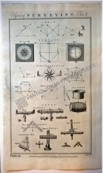
Genuine Antique Print, Copper Engraving, System of Surveying, Alexander Hogg, 1788
Title: System of Surveying Tab. I
Technique: Antique Copper engraving engraved, printed on hand made "Laid" made from hemp and flax.
Description: Features a series of figures illustrating survey applications & equipment used in the late 1700s while demonstrating perspective diagrams where and how such equipment is used: Chain, Compass, Circumferentor, Frustum, Gauging, Level ( Air Level, Foot Leve, Plumb Level, Huygens Level, Plumb Level, Gunners Level)
Published: "According to an Act of Parliament" by Alexander Hogg, at the Kings Arms No 16 Paternoster Row, London circa 1788
Condition: Excellent. Hand made flax & hemp "Laid" paper has a very light grey smudge half way down left border, complete platemark.
Size: Plate mark = 23.5 x 38 cm /9.4 x 15.2 inch
Land Surveying
Surveying or land surveying is the technique, profession, and science of determining the terrestrial or three-dimensional position of points and the distances and angles between them. A land surveying professional is called a land surveyor. These points are usually on the surface of the Earth, and they are often used to establish land maps and boundaries for ownership, locations like building corners or the surface location of subsurface features, or other purposes required by government or civil law, such as property sales.Surveyors work with elements of mathematics (geometry and trigonometry), physics engineering and the law.


