 Loading... Please wait...
All prices are in All prices are in USD
Categories
- Home
- Giclee Prints
- Giclee Maritime Explorers South Hemisphere Polar French
- Home
- Giclee Prints
- Maps and Charts
- Giclee Maritime Explorers South Hemisphere Polar French
- Home
- Giclee Prints
- Maritime
- Giclee Maritime Explorers South Hemisphere Polar French
- Home
- Giclee Prints
- Maps and Charts
- Australia-Asia-Pacific
- Giclee Maritime Explorers South Hemisphere Polar French
Product Description
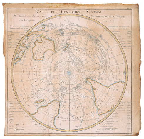
Giclee, Map, Southern Hemisphere chart of Maritime explorers, Mendana to James Cook, Polar World view, Paris, 1550 to 1777
"Carte de l’Hemisphere Austral Montrant les Routes de Navigateurs les Celebres par le Captaine Jacques Cook"
Size of image = 53cm x 54cm (211/6 x 211/2)
Conservation Edition Limited to 350 each image. Issued with numbered certificate
Description: The original French antique map is hand coloured, unusually featuring the Southern Hemisphere, and focusing on the recent second voyage of Capt James’s Cook, including the comparative documented tracks of other Maritime explorers back the 1500s through to subsequent voyages. It is drawn in a semi-circular polar-projection. The discoveries and destinations of Cooks voyages are listed outside the hemisphere circle. Within its confines we see detailed routes of the tracks of French, English, Portuguese, Spanish and Dutch Voyages of Explorations including Mendana, Tasman, Cataret, Byron, Bourgainville, Furneaux and others. To give visual orientation to the viewer, we see the continents of South America, Africa, New Holland (Australia with Tasmania attached), the Pacific & Islands, the Southern Atlantic & Islands, but no Antarctica, yet. The original map was engraved for the French Publication “Abrege de ll’Histoire General des Voyages”. Most notable are the tracks of Captain James Cook’s two of voyages (1768-1772,1772-75). We see the repeated entries into the Antarctic Circle by Cook over a three year period on his second voyage circumnavigating the globe following 60 degrees latitude. This is the first map of this kind to catalogue the history of maritime explorers tracks compared to the achievements of Captain Cook. The antique map was published by George Forster in London in 1777. Forster’s map was actually published some weeks before Cook’s own official version appeared for the perusal of the public. By virtue of this map being not attributed it is undoubtedly a French copy of Foster’s map.
Others Explorers Tracks shown are;
Alvaro Mendana (Spanish) ~ Pedro Fernandez de Quiros (Portuguese) ~ Edmund Halley (English) ~ Abel Jansoon Tasman (Dutch) ~ Commodore John Byron (English) ~ Louis-Antoine comte de Bougainville (French) ~ Samuel Wallis & Philip Cateret (English) ~ Jean Francois Marie de Surville (French)


