 Loading... Please wait...
All prices are in All prices are in USD
Categories
- Home
- Giclee Prints
- Giclee, discoveries, Asia, Pacific, Australia, Captain Cook, lodge, 1797
- Home
- Giclee Prints
- Maps and Charts
- Giclee, discoveries, Asia, Pacific, Australia, Captain Cook, lodge, 1797
- Home
- Giclee Prints
- Maps and Charts
- Australia-Asia-Pacific
- Giclee, discoveries, Asia, Pacific, Australia, Captain Cook, lodge, 1797
Giclee, discoveries, Asia, Pacific, Australia, Captain Cook, lodge, 1797
Product Description
Giclee, Archival Limited Edition, Maps, Asia & the Pacific, Australia, Captain Cook, Norfolk Island, Port Jackson, North America
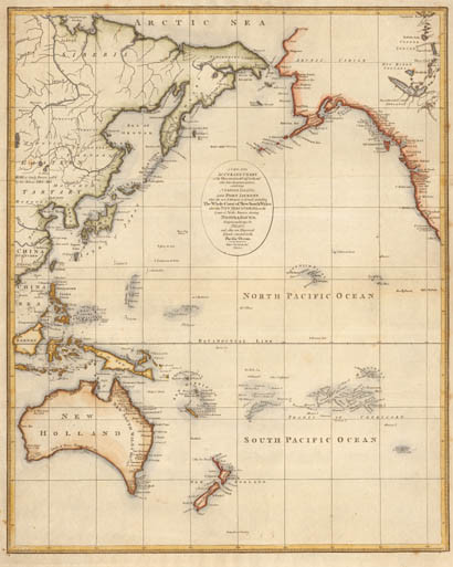
A new and accurate chart of the discoveries of Captn Cook and other later circumnavigators, exhibiting Norfolk Island and Port Jackson where the new settlement is formed, including the whole coast of New South Wales : also the new discoveries on the coast of North America, shewing Nootka Sound, comprising likewise the Pelew and other new discovered islands situated in the Pacific Ocean."
Size of image = 34cm x 42cm / 131/2 x 163/4 Inch)
Archival Edition Limited to 350 each image. Issued with numbered certificate
Description: Originally Engraved by John Lodge Junior and published London 1797, this map of the Pacific Ocean depicts Australia as New Holland, (not named Australia until Matthew Flinders published the account of his Voyage, Voyage to Terre Australis , in 1814 ) with the East Coast place names as given by Captain Cook, and Van Diemen’s Land linked to the mainland. (George Bass and Flinders circumnavigated the island in 1797 but the knowledge did not reach the Amiralty until 1799). It names and dates the Principal Dutch discoveries on the West coast. Lodge Jr. gives a more detail depiction than on any map so far and includes Adventure Bay and Cape Tribulation. Note the area of the south Australian gulfs first published by the French in 1811, is noted here as a dotted line, hence designated "unknown".
Other Details
Product Reviews
-
Awesome Navigation Skills

Posted by Lorren on 11th Oct 2012
It's a pleasure to find someone who can identify the issues so clearly. Captain James Cook was an awesome navigator in both hemispheres.
-
zfAhSvKDz

Posted by Geraldine on 10th Sep 2011
Check that off the list of things I was confused about.
-
Land AHOY!

Posted by Ella on 9th Sep 2011
So excited I found this map as it has helped illustrate my research making things much quicker! A map does "paint a thousand words"
-
tdPULXityjwCL

Posted by Amber on 9th Sep 2011
A mnitue saved is a minute earned, and this saved hours!
-
AnaDqSvTmrgMc

Posted by Latricia on 8th Sep 2011
The original engraving was impossible to source so thanks for this! He discovered so much more than the East Coast of Australia by the way...this is proof!


