 Loading... Please wait...
All prices are in All prices are in GBP
Categories
- Home
- Antique Prints
- Children Topic
- Illustrators- International
- Children Nonsense Rhymes Darton Academic Penguins Antique Print
- Home
- Antique Prints
- Children Topic
- Children Nonsense Rhymes Darton Academic Penguins Antique Print
Product Description
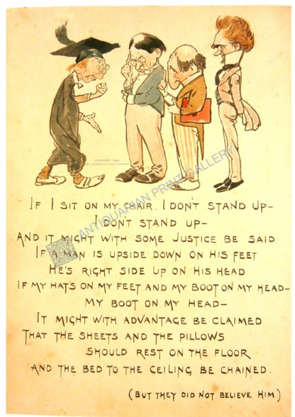
Children Nonsense Rhymes "If I Sit on My Chair..." and "The Nautical Man of Torbay..." 1896
Antique Chromolithographs by illustrator Joseph William Darton for a collection of nonsense Rhymes by his pseudonym A. Nobody Dedicated to "For Somebody, Anybody or Everybody Paricularly the Baby Body"
Printed by Wells, Gardner, Darton & Co, "Designed in England, Printed in Holland, On English Paper" London c.1896
"If I sit on my char, I don't stand up-I don't sit down..." features Academics discussing the Laws of Physics (Maybe)
On reverse side: "That Nautical manmof Torbay Wobbled and Rolled all the Way..." features penguins, a turtle and a keg
William Darton (February 2, 1881 - July 28, 1854) was an English publisher and engraver active in Tottenham London during the early part of the 19th century. Darton was the eldest son of William Darton Sr., himself a printer and publisher who co-owned the firm of Harvey and Darton. Darton, a Quaker, was educated at the Friends School in Clerkenwell, London and the Ackworth School in Yorkshire. Afterwards Darton apprenticed to his father where he mastered the part of printing and engraving. Around 1804 Darton opened his own shop, the "Repertory of Genius", specializing in maps, prints, children's books, educational publications, and other "works of merit" at 50 Holborn Hill, London. Cartographically Darton's most significant contribution is his 1823 publication, along with engraver W. R Gardner, of the first composite comparative mountains and rivers chart. Darton also published various maps for the 1802 Atlas to Walker's Geography and his own 1813 Union Atlas. Darton retired in 1851 leaving his business to his son, John Maw Darton, who partnered with Samuel Clark and published as "Darton and Clark".
William R. Gardner (fl. c. 1810 - c. 1850) was and English engraver active in London during the first half of the 19th century. His offices were at 867 Strand Street, London. Gardner worked with many of the most prominent London publishers of his day including Charles Smith and William Darton. His most significant contribution to the world of cartography is his 1823 publication, along with publisher William Darton, of the first composite comparative mountains and rivers chart.
William Darton (February 2, 1881 - July 28, 1854) was an English publisher and engraver active in Tottenham London during the early part of the 19th century.Joseph Wiliam Darton was the eldest son of William Darton Sr., himself a printer and publisher who co-owned the firm of Harvey and Darton. Darton, a Quaker, was educated at the Friends School in Clerkenwell, London and the Ackworth School in Yorkshire. Afterwards Darton apprenticed to his father where he mastered the part of printing and engraving. He was a member of the Darton family who were publishers of children’s books from 1787 to the end of World War I (1918) Joseph William Darton, Jr. was a trained printer and engraver and it is believed he designed and created games to sell at his shop in London The Repertory of Genius.
Size = 210 x 285mm
Condition = Excellent


