 Loading... Please wait...
All prices are in All prices are in AUD
Categories
- Home
- Giclee Prints
- Giclee Map New South Wales Port Jackson 1791 Dawes Tench
- Home
- Giclee Prints
- Maps and Charts
- Giclee Map New South Wales Port Jackson 1791 Dawes Tench
- Home
- Giclee Prints
- Maps and Charts
- Australia-Asia-Pacific
- Giclee Map New South Wales Port Jackson 1791 Dawes Tench
Giclee Map New South Wales Port Jackson 1791 Dawes Tench
Product Description
Giclee, Map, Australian East Coast, Port Jackson, NSW, 1791, William Dawes, Watkin Tench, New South Wales
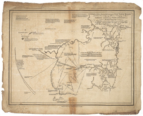
"A map of all those parts of the territory of New South Wales which have been seen by any person belonging to the settlement established at Port Jackson in the said territory...respectfully inscribed to Capt. Twiss of the Royal Engineers...by his much obliged and Humble Servant William Dawes"
Archival Limited Edition of the original map published by John Stockdale in Piccadilly, London, September 22nd, 1792 after Captain William Dawes. It depicts the coast from Broken Bay to Botany Bay and the hinterland to the 'Camarthan Mountains', what we now identify as, the Blue Mountains. The annotations on the availability of water, topology, soils condition were acknowledgement to appeal to free setters to the Antipodean colony. It shows the tracks of explorers, most notably William Dawes, who were mapping the course of the Hawkesbury-Nepean river system and the intended tracks of explorations planned in winter, 1791. The straightness of the explorers tracks shows their use of the compass course. They also measured distance by counting their military paces (2200 to the mile!) ~Perry /Prescott, 1996.
Only some of the intended explorations were undertaken and this map was updated in Watkin Tench's publication, "A Complete Account of the Settlement of Port Jackson" published in 1793.
Size of image = 56cm x 46cm (22 1/3 x 18 1/3 inch)
Archival Edition Limited to 300 each image. Issued with numbered certificate
Product Reviews
Showing reviews 1-6 of 7 | Next
-
Precious measurement!

Posted by Abderrahim on 12th Oct 2012
THe idea of Redcoats (lobsters) marching about counting their military footsteps to the mile across such terrain is fantastic! Now I have the map there is so much more to be revealed so early in the Convict colony's history!
-
Before Survey Equipment-Impressed

Posted by Keydrick on 11th Oct 2012
That's the thinking of a creative practical mind.
-
Intriguing map.

Posted by Edward on 21st Jan 2012
I am so pleased with this map. It is humbling to imagine soldiers stumbling around this landscape in marching boots! It is amazingly accurate considering the technology of the time! I am impressed!!!
-
eVkHFtCHPp

Posted by Kamren on 9th Sep 2011
WOW! Watkin Tench's map of the Port Jackson hinterland. This is such a find!
-
ljcJkZNIfzKiNoso

Posted by Barbi on 9th Sep 2011
This was the perfect gift for one whom I love! Thanks HEAPS and HEAPS!!!!
-
VEOrhUprltVnbI

Posted by Travon on 9th Sep 2011
Super jazzed about how they measure distance with the military marching,, and over that terrain!
Showing reviews 1-6 of 7 | Next


